Route & what to see
![]()
|
A Shirley Walk Route & what to see |
|
london-footprints.co.uk |
A 5 mile walk around Shirley which
starts at the Methodist Church at the junction of Shirley Road
and Wickham Road. This is served by several buses or the route
can also be accessed from Lloyd Park (via Coombe Road) or Coombe
Lane tramstops.
The terrain of Addington Hills and Oaks Lane makes it unsuitable
for cycles, wheelchairs, buggies etc. There are several pubs on
the route and there is a cafe in Coombe Wood. Shirley Windmill
opens for tours on occasional Sundays or by arrangement for
groups.
From the church go along
Wickham Road
There are old cottages at numbers 23-29 and the smithy was
adjacent to number 23. The Shirley Village building of 1888 was
initially used as a Croydon Library. Shirley Cottage was an early
18th century house converted to flats between the wars. Its coach
house formed the front of the Parish Hall to which the main hall
was added in 1930. Also on the left is the entrance to Shirley
Oaks which began as an orphanage (see plaque). On the right West
Way Gardens was the drive to Spring Park and its 18th century
thatched lodge remains.
Continue along Wickham Road to
Cheston Avenue
The ornamental lodge on this corner marks the route of the drive
to the Monks Orchard Estate.
Return along Wickham Road to
Shirley Library.
This was built in an Art Deco style. The village sign outside
shows the Shirley Poppy.
Go left along Hartland Way and
right at West Way Gardens.
This gives a closer view of the thatched lodge.
Go left into Wickham Road and
left along Spring Park Road
The Shirley Inn is mid 19th century. There are old cottages at
numbers 55-63.
Opposite the bowling green go
through the gate on the right into the churchyard.
St John's Church built in 1854 to the designs of Sir Gilbert
Scott has some fine tombs and monuments.
Go around the church, exit via
the gate by the lychgate into Shirley Church Road and go right.
On the old vicarage there is a plaque to Rev William Wilks who
was vicar 1879 - 1912 and was responsible for developing the
Shirley Poppy. Adjacent to this house is Hall Grange home for the
aged.
Continue to the end of Shirley
Church Road and cut across the grass left into Upper Shirley Road.
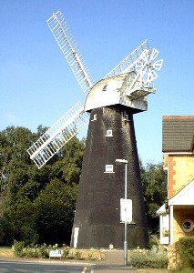
On the right is the Shirley Windmill (pictured in header), now
amongst modern housing. The brick tower mill replaced an earlier
post mill which burnt down in 1854. Further along on the right
are the Surprise pub, commemorating the rare Camberwell Beauty
butterfly and Windmill House (rebuilt in 1983) formerly the coach
house to 'the Ferns' (demolished). On the left are a pair of 18th
century cottages (numbers 110-112). A short cul-de-sac between
numberts 118 & 128 would have led to the smithy and The Old
Forge remains at number 120. The post office operated from number
132.
Continue along Shirley Hills
Road
The Sandrock pub has sand pits behind. Further along is a house
with a bell tower converted from a mission church and school of
1874.
Just past this building take
the path off to the right and after a short distance the path
going down to the right. Follow the roadway at the bottom (noisy
dog!).
This is Badger's Hole which began as a site for temporary homes
of casual workers which have been demolished or rebuilt over time.
At the end turn left then
follow the London Loop signs to the left.
The route goes up through Addington Hills to a viewpoint. A new
landmark visable from here is the Wembley Stadium.
On the opposite side of the viewpoint go down stony steps. At the bottom go right then left around the hill. When you reach 2 silver birch trunks on the left and a fallen tree root on the right take the path to the right. Continue ahead towards the traffic noise. At the road cross and walk to the left (care at tram crossing ahead). Cross Coombe Lane with care into Conduit Lane opposite and enter the park on the left.
Note: the following is a
suggested route around the more formal parts but you may wish to
explore Coombe Wood further.
Past the pond go left through the rock garden which emerges in
the rose garden.
The pond was dug out in 1845. Many of the rocks in the rock
garden are artificial. The roses were donated by Nestle of
Croydon in 1971 when a postal strike prevented them being
dispatched as a free offer.
Go across or around to the
exit by the cedars opposite then left along the path in front of
the shelter. Go right through the winter garden.
To the left is Coombe Wood House built in 1898, now a restaurant.
Follow the log-lined path
around to the right back to the rose garden gate then take the
path to the left.
There is a large beech tree on the right.
Go to the right by tall pines
and walk through the grassed Broad Walk to the right.
This is planted with herbaceous plants.
At the sundial go left around
the terrace gardens down to the main path.
To the right the former stables now house the cafe and toilets.
Exit the park by the pond,
cross back to Oaks Road and beyond the tram route take Oaks Lane
to the left.
The thatched cottage on the corner was originally transported on
wheels from Coulsdon but has since been extended. Further along
on the left, past playing fields, is Coombe Farm and beyond it an
old chalk quarry.
Continue ahead
On the left is Oaks Farm, once in the ownership of the
Archbishops of Canterbury. The lane crosses Shirley Park Golf
Course beyond this.
Exit through the gate into Upper Shirley Road and go left back to the start of the walk.
Resources
The main source of information for this walk was 'Living History
Local Guide No.2 - Coombe Shirley & Addington'. This may no
longer be available to purchase but Croydon Library will have
copies. The local studies department will have much more
information on the area [see Research]
© london-footprints.co.uk 2004
[places to visit] [trails] [walks list]