Route & what to see
![]()
|
A Kingston Walk Route & what to see |
|
london-footprints.co.uk |
A walk looking at the historic aspects of Kingston. The route suggested starts from Hampton Court Station and begins with a 3¼ mile riverside walk to Kingston Bridge. Alternatively this can be reached from Kingston Station giving a shorter circular walk although the section to the bridge does not have much of interest.
CIRCULAR WALK FROM KINGSTON
STATION
Cross the road and go right along Wood Street. Bear left around
Bentalls then cross and walk along the right hand side of
Horsefair, the road going under John Lewis. At the bridge go down
the steps (signposted 'Royal Barge') to the riverwalk. Follow
route detailed below.
LINEAR WALK FROM HAMPTON COURT
STATION
Cross the bridge and go down to the riverwalk following this past
the gardens of Hampton Court Palace
There are views of the Banqueting House then the Privy
Gardens and east front of the palace through the Tijou Screen.
Further along are Home Park Golf Course and the Wilderness.
Go up to and cross Kingston
Bridge. Take the steps down to the riverwalk and go under the
bridge.
Kingston had the first bridge above London. This wooden structure
was replaced by the present bridge in the 1820s, widened in 1914.
The location of the old bridge is marked by the cobbled remains
of the approach road on the riverwalk. Visable in the basement of
the nearby John Lewis building is a 600 year old undercroft from
the Rose & Crown Inn found and preserved with the
redevelopment.
Follow the John Lewis building
around to the right (Vicarage Road). Cross Horsefair and go right
into Wood Street
This frontage of Bentalls store was designed by Maurice Webb in
1935 and based on Hampton Court Palace. The adjoining building
was rebuilt in 1990 and the Bentalls Centre, designed by BDP,
opened in 1992. The John Lewis store opened in 1990 on a site
cleared in 1937.
Cross Clarence Street to All
Saints Church
There has been a church since Saxon times but the present Grade I
listed building is part 14th & 15th century with Victorian
restoration. The gates were presented to the East Surrey Regiment
(once garrisoned in Kingston) in 1924.
Take the road alongside the
church into Church Street
The building occupied by Monsoon was built as Kingston's first
savings bank in 1819. Numbers 6 & 8 were once the Rose
Tavern.
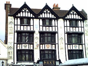
Go right into Market Place
The building occupied by Jack Wills had its 'Tudor' facades added
in 1909 & 1929 [pix] but the corner premises next door date to
1570. The main structure of Bradford & Bingley Building
Society building also dates to the 1570s. Neighbouring Millets
was an elegant restaurant from 1901 to 1932 when the ground floor
was converted into a shop. The riverside frontage will be seen
later on the walk.
Continue around Market Place
The market was laid out around 1170 and has charters granted in
1208 and 1628. The Market House was built as the Guildhall in
1840 by Charles Henman and used as such until 1935. It was
refurbished in 1995 and now houses Visitor Information. The
gilded statue of Queen Anne of 1706 came from the previous
building. The Rymans shop was the former Wheatsheaf Inn which
closed in 1962. The statue of a lady holding an urn by Francis
Williamson is a memorial to William Shrubsole, three times Mayor
of Kingston who died in office in 1880. The Druid's Head is
Kingston's oldest pub dating from the 17th century. The Griffin
building was a former hostelry with assembly rooms converted into
shops in 1986. Borders Bookshop replaced Hides Department Store
but retains a Jacobean oak stair from the earlier Castle Inn of
1537.
Go through the Griffin Mall
This leads to the Hogsmill River with a view of the part 12th
century Clattern (originally Clattering) Bridge [pix].
Walk alongside the river
towards the Thames.
This area has been redeveloped
as Charter Quay. A kiosk incorporates roof timbers from the
former Castle Inn (see plaque). To the right is a view of the
gazebos of the former Nuttalls Restaurant.
Cross the Hogsmill River to
the left and continue along the riverwalk.
The Gardens of Queen's Promenade opened in 1856.
From the gardens return along
the High Street.
The block which includes Pizza Express dates from around 1550 and
is a rare survivor of an open-hall house. Further along on the
left is Amari House, the home of Cesar Picton (see plaque). He
had been sent from Senegal as a boy servant to Sir John Phillips.
A family bequest of £200 enabled him to set himself up as a coal
merchant. Kingston's theatre, based on the Rose Theatre in
Southwark, opened in 2008. [website].
Cross the bridge and go into
the Guildhall complex.
This replacement building by Maurice Webb was completed in 1935
and incorporates linenfold panelling from the old Tudor town
hall. Victorian railings surround the Coronation Stone on which 7
Saxon kings are said to have been crowned in the tenth century.
Walk alongside the river and
at Guildhall 2 (1981) go left through to St James Road going left
along this road
At the top is a view of the United Reformed Church of 1855,
reconstructed in 1977. On the corner is Eagle Chambers of 1879
built on a site previously used as a slaughterhouse and a
cooperage.
Go left along Eden Street and
right into Apple Market
The Market Bakery was originally the Harrow pub of 1530,
converted to shops in 1913.
Go right through Crown Arcade
and left into Union Street
The Baptist Church of 1864 replaces a building of 1790. The
building occupied by Bonbon Patisserie was built in 1825 as the
watch house. It later became a mortuary and was converted into a
shop in 1939 with the upper storey added in the 1950s. Adjacent
to this was an extension to the churchyard used 1826-1855. It was
cleared in 1923 and landscaped as a Garden of Remembrance for
servicemen of WWI.
Go right along Clarence Street
At the end of the pedestrianised section there is a view to the
left of the former Kingston Empire of 1910 (now Wetherspoons)
closed in 1955. Opposite Oceana occupies the former Granada
Cinema of 1939 designed by George Cole. The Italian Renaissance
interior by Theodore Komisarjevsky was saved by listing in 1989.
To the right along Wheatfield Way is Kingston Library (1903) and
the Museum (1904) both built with contributions from Andrew
Carnegie.
Cross into Old London Road
There is an unusual sculpture of leaning telephone boxes called
'Out of Order' created by David Mach in 1989 [pix]. Opposite was Kingston's first police
station built in 1864 and used until 1968 [pix]. Next door at number 24 are the historic
premises of Fredrick W Paine - Undertakers. Mr Paine lived above
the shop and their records date back to 1896 (useful for family
historians). Further along the Oxfam shop, once the Three Coneys
alehouse, was built around 1660 in local hand made bricks. On the
left hand side are Cleave's Almshouses built in 1669 for 6 poor
men and 6 poor women [pix]. Other dwellings were added and it still
serves as almshouses. At the end of the road is the Lovekyn
Chapel endowed in 1309 and rebuilt in 1350. It is now part of
Kingston Grammar School, founded by Elizabeth I in 1561.
Go left along Queen Elizabeth
Road and left into Hardman Road.
On the right are the premises of Kaleidoscope, a project working
with marginalized people in conjunction with John Bunyan Baptist
Church. At the end is Bentalls Depository built by
Maurice Webb in 1939 on the site of Austin's Jam Factory. It was
saved from demolition and now houses leisure facilities including
cinema screens.
Go left along Cromwell Road to the station
© london-footprints.co.uk 2012
[places to visit] [trails] [walks list]