![]()
Route & what to see
![]()
|
GREEN
DEPTFORD WALK Route & what to see |
|
london-footprints.co.uk |
This walk of 3¼ miles links some of Deptford’s green spaces. The notes give information on each including how they came about and what was there previously.
ROUTE: Elverson Road DLR Station – Brookmill Park – Deptford Bridge – Deptford Church Street – Reginald Road - Creekside – Ferranti & Sue Godfrey Parks - St Paul’s Churchyard - Deptford High Street – Albury Street – McMillan Street – St Nicholas Churchyard – Charlotte Turner & Twinkle Parks – Watergate Street – Edward Street - Clyde Street – Evelyn Green – Arklow Road - Amersham Grove/Vale – Royal Naval Place Allotments - Margaret McMillan Park – Watson Street - Douglas Way – The Albany
INTRODUCTION
Deptford had two centres of settlement - the riverfront and area
around the church and at Deptford Bridge. These were linked by
Church Street (now dual carriageway) and Butt Lane (now the High
Street). The naval dockyard was established by Henry VIII in 1513
and brought people and prosperity to the town. In 1698 the
population was 10-12,000 - only Norwich and Bristol were larger
towns. Although the dockyard and associated industries provided
much employment farming and market gardening was also important
with ready access to London markets. Even when the London to
Greenwich railway was opened in 1836 much of its 4 mile route was
across market gardens and meadow land. After the dockyard closed
in 1869 (to become a foreign cattle market) the character of the
area changed. Heavy and unpleasant industries began to dominate
leading to a largely poor population living in deprived
conditions. A number of philanthropic initiatives were set up to
help local people. Deptford suffered badly in WWII bombing. By
1944 almost everything had been damaged and 648 people killed.
Deptford became part of the Borough of Lewisham in 1965 and the
schemes which replaced old and damaged houses did the area no
favours! In more recent times a number of rebuilding and
regeneration projects have been undertaken.
 |
BROOKMILL
PARK The River Ravensbourne was used as a source of water by Deptford Waterworks, founded in 1701 as part of the Ravensbourne Water Company, which become Kent Waterworks in 1809. By the 1840s the company had a small reservoir surrounded by grass and trees on the site of the current Brookmill Park, adjacent to which a small recreation ground existed from 1880. The river ceased to be used for water supply in 1862 and by 1900 the reservoir was also disused, no longer adequate for the growing population. In the 1920s the recreation ground was expanded when part of the reservoir was infilled. Some evidence of this remains, much reduced in size, as the small oval lake in the park (pictured left). |
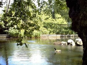
The northern area of the park, known as Broadway Fields, was used for market gardening. This became Deptford Municipal Playing Fields in 1932 and an extension across the Ravensbourne River was added in the late 1930s. When housing in Brookmill Road was destroyed by bombing in WWII, the park was further extended and re-opened in September 1951, renamed Ravensbourne Park. Ornamental gates with this name were installed in 1953 in commemoration of Queen Elizabeth's Coronation. When Deptford became part of Lewisham in 1965, the park reverted to the original name of Brookmill Park to avoid confusion with Ravensbourne Park Gardens in Ladywell. In the 1990s the construction of the Docklands Light Railway extension required the course of the Ravensbourne to be moved as the new railway was partly following the concrete-sided channel of the river. This resulted in the majority of the park to the east of the river being given over to the DLR. The Ravensbourne was re-routed into a new, 'natural' channel running along the eastern boundary of the park, offering new habitats for wildlife including kingfishers. The lake was drained when the re-routing was carried out but has been restored as a result of local campaigning. It is fenced and its central island was removed in order to discourage Canada Geese.
 |
The former Thames Water gardens were added to the park and re-landscaped to create a formal garden (pictured left) with pond, pergolas, ornamental beds and hedges and re-opened in July 1998. The park also has a play area, nature reserve and ranger’s office. There are a number of mature trees including some fine Planes around the lake, as well as many conifers and various areas of shrubbery. In the south native shrubs have been planted on a former railway embankment. This carried a branch line that ran from Nunhead to Greenwich Park Station (site of Hotel Ibis) which closed after WW1. |
REGINALD ROAD
On 16 June 1944 a flying bomb exploded in Reginald Square killing
22 people and causing widespread damage to its Victorian houses.
The area between Reginald Road and Frankham Street was
subsequently cleared apart from the school which received minor
damage. Demolished buildings included a mission hall. The green
area behind wire fences is used by Tidemill School.
|
|
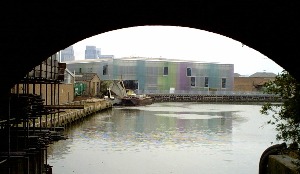
| LABAN The Laban Dance Centre occupies the site of a former Deptford Borough Council yard. The building was designed by Herzog & De Meuron, architects of Bankside Power Station/Tate Modern. Constructed in 1997-2002 it won the Stirling Prize for Building of the Year in 2003. The grounds have been landscaped into an amphitheatre which can be used for performances and the building has a ‘brown’ roof. The cafe and some shows are open to the public. www.laban.org |
|
 |
FERRANTI
PARK A £0.5 million project funded by Lewisham Council and the LDA has transformed a disused road salt depot into a new park, officially opened in June 2004. The name of the award winning park was chosen by a local resident in a competition. In 1889 the world’s first electric power station to generate at high tension (up to 10,000 volts) was built at Deptford by Sebastian De Ferranti who went on to establish the principle of the national grid. The buildings were finally demolished in 1992 and the site is now occupied by Fairview Housing. |
| SUE GODFREY
NATURE PARK Potteries and lime kilns were established here in 1701 and run by the Parry family for 190 years. Colour works are shown on a map of 1867. During WWII a V1 landed in Creekside and properties in Berthon Street and Bronze Street were damaged beyond repair. The Gibbs & Canning industrial pottery on the site was demolished in 1967. There is a small plaque on the remaining wall to commemorate Sue Godfrey, a local campaigner, who was killed in a road accident. |
|
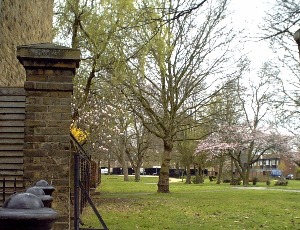
ST PAUL’S CHURCHYARD
St Paul's was built as one of the ‘50 New Churches’
following a petition by the vestry of St Nicholas for a second
church at Deptford, accepted in 1711. The Commission required a
burial ground for the new church to have stone walls and iron
gates to keep grave robbers out. The site chosen was land
originally owned by Henry Wise, the Royal Gardener, who had sold
it in 1710 to his brother Richard, a master caulker in Deptford
Dockyard, who then sold the land to the Commission for £640. At
that time the land was used as a market garden by Samuel
Preistman who was compensated £80 for loss of fruit trees,
asparagus plants and dung. Five houses along the Church Street
boundary were also demolished. The Baroque style church was
designed by Thomas Archer in 1713 and consecrated in 1730. An
estate map of 1744 recorded the area to the east of the church as
the 'best burial ground'. In the churchyard is the grave of
Mydiddee, a Tahitian who came to England with Captain Bligh on
HMS Providence and who died in Deptford on 4 September 1793. By
the time the 1852 London Burial Acts were passed St Paul's
churchyard was crowded, presenting a health risk and it closed
for burials in October 1854. Although it temporarily re-opened in
June 1856 due to delays in establishing a new cemetery it was
finally closed in 1858. Some tree planting was carried out in the
1890s and in 1910 an Act of Parliament enabled former burial
grounds to be converted into public gardens. The headstones were
moved to the perimeter and walks laid out with trees planted
alongside. The southern boundary has planes and limes, and there
are older planes along the north boundary. The whole site is
walled with railings and gates at the western entrance. Features
include a drinking fountain in the south-east corner, bedding and
shrubberies and serpentine paths. Fine monuments include several
table-tombs and an obelisk to the Stone family of 1807. The
former charnel house east of the church is now a store. There are
open spaces outside the walls to the east and south. The church
entrance forecourt was re-landscaped by Alan and Sylvia Blanc as
part of improvements works to the High Street in June 1973. The
Rectory designed by Thomas Archer on Crossfield Street had been
demolished c1885 after it had been sold to the Improved
Industrial Dwellings Company in 1882. The tenements and cottages
built on the site were later destroyed during WWII and the land
is now additional public open space. Demolition of houses and a
Unitarian chapel also cleared an open space to east of the
churchyard. The gravelled area behind the church has good ferns,
including a colony of wall-rue on the south side of the church by
the Crypt, rare in London. Between Crossfield Street and the
churchyard is Crossfield Open Space, once formally landscaped
until it became a wasteland following road building across it in
1998. www.paulsdeptford.org.uk
THE MCMILLAN NURSERY
The McMillan sisters Margaret and Rachel, born to a Scottish
family, did much for the health and education of Deptford people.
They established night camps, the girls’ at 353 Evelyn
Street and the boys’ at 24 Albury Street providing washing
facilities and clean clothes. The boys also slept outdoors among
the graves of St Nicholas Churchyard! The sisters believed that
early years' education could counter some of the effects of
poverty and established a nursery school which remains. The Herb
Garden opposite was set up in the 1990s and is open weekends. [website]
|
|
|
CHARLOTTE
TURNER A map of 1868 shows this area as a disused burial ground. Two stones are set into the present boundary wall. The inscription on the lower one reads ‘The stone above this is the stone which was removed from the wall which originally marked the northern boundary of the St Nicholas Deptford garden such wall having been removed when the additional land northwards was added to the garden in 1897. The iron fence now marks the position of that wall. A Golding chairman of the St Nicholas Deptford committee.’ The upper stone to which it refers is not readable. |
In the 1860s three streets and a rope walk ran north to south between Old King Street (now Watergate Street) and Deptford Green. By 1894 there was a school north of Benbow Street and the burial ground had become Hughes Fields Recreation Ground. Armada Street (once New Street) was cleared for LCC tenements by 1900. A Zeppelin raid in 1915 hit the area and a VI fell during WWII. The present linear park has been re-landscaped to the designs of David Ireland and links with Twinkle Park. There is a sundial which requires a human gnomon. Charlotte Turner JP was a member of Greenwich Borough Council and other public bodies. She served as Mayor of Greenwich for 1931-3, the first woman to hold the post.
TWINKLE PARK
A map of 1868 shows two pubs at the northern end of Watergate
Street (then Old King Street). By the 1930s only one pub and a
couple of houses remained on the corner plot which had included a
recreation ground since at least 1914. This was supervised by Mrs
Twinkle. It became derelict and neglected until in 1992 local
residents from Rowley House working with Greenwich Mural Workshop
began a campaign to restore the park. Other groups became
involved including council architects in charge of expanding the
nearby school. The space now serves the community and the school
with wildlife areas, a pond, floodlit ball game area, play boat
and gazebo. Several large Plane trees have been retained. The
park was formally opened in 1999.
EVELYN GREEN
This provides a green corridor and play space between housing and
the railway. Before WWII Childers Street (once James Street &
Henry Street) and roads to the north had terraced houses. John
Evelyn, the other diarist, lived at nearby Sayes Court where he
laid out a fine garden (trashed by Peter the Great!).
 |
New Deptford Green across the railway was was cleared in the 1970s except for the institute and two houses and subsequently used to build the houses of Trim Street and Kerry Road. The Coffee House and Institute had been used mainly by men working in Stone’s Engineering Works opposite. In the 1920s it was purchased and renamed Lady Florence House but was bricked up when this Fund left Deptford in the 1970s. Stones moved to Arklow Road in 1881 and by 1950 the works covered six acres. The business relocated in 1966 and the factory closed in 1969. |
ROYAL NAVAL PLACE ALLOTMENTS
In the 19th century Amersham Vale and the streets
around it had mainly two storey terraced houses, often with two
families or lodgers. In the 1890s Charles Booth employed people
who went around the streets of London with local constables
surveying and categorising properties. Their notebooks enabled
Booth to complete his ‘Poverty Maps’ with streets
coloured according to the condition of inhabitants, ranging from
wealthy yellow to semi-criminal black. The streets in this area
were rated a mid purple or a higher pink. In Amersham Grove a
double fronted house was occupied by an old sailor who built a
small museum in the garden and stocked it with curios. This
building still exists and is undergoing restoration. In Napier
Street, which ran parallel to Amersham Grove, Booth’s
researcher recorded four boys playing cricket in the street who
ran away on seeing the policeman! Houses here were subsequently
cleared and areas either side of Royal Naval Place provide
allotments. There are 28 plots with a 3½ year waiting list.
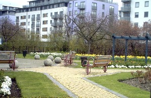
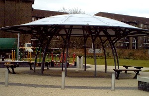
MARGARET McMILLAN PARK
Margaret McMillan Park opened in 1954 and was originally laid out
between Watson's Street and Glenville Grove with a series of
lawns along Douglas Way where properties had been bombed. The
engineering works of Clarke, Burnett & Co, employing 100 men,
had been sited on the east side of Glenville Grove. In the late
1980s part of park was eroded by housing development.
Improvements made in 1998 included a new playground and a
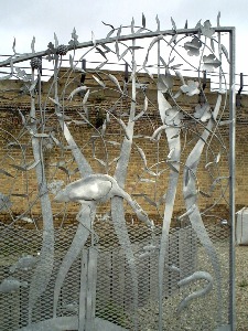
sculptural feature in the form of a stone bridge created by John
Maine and members of the local community.
THE ALBANY
The Albany Institute was founded in the 1890s and operated from
premises in Creek Road. It was gutted by fire in July 1978 and
demolished in 1981 to be replaced by a new building in Douglas
Way. The Albany is now a multi-use performing and digital arts
venue working with diverse local community groups including young
people, the disabled and families. It offers a theatre, cabaret
& studio space and community rooms. The cafe which opens out
into a garden with raised beds and seating is open to all. www.thealbany.org.uk
Resources
Turning the Tide – the History of Everyday Deptford by Jess
Steele
London Parks & Gardens Trust – Inventories for Lewisham
& Greenwich
Lewisham Local Studies & Archives at Lewisham Library,
199-202 High Street SE13 [more info]
Old photographs can be accessed on www.portcities.org.uk/london/ Search 'Deptford'
Booth’s maps and notebooks are available online http://booth.lse.ac.uk
A complete set of Bomb Maps (showing where bombs fell and the
extent of damage) are availbale at the LMA [more info]
ã london-footprints.co.uk 2010