Route & what to see
![]()
|
A Barnsbury Walk Route & what to see |
|
london-footprints.co.uk |
The area west of Upper Street Islington was developed in the 1820s-1840s. Soon after the railways tempted people further out and until the 1960s the area was out of favour. However, its attractive villas, terraces and squares, in a variety of styles, thus escaped improvement and feature on this 3½ mile circular walk from Angel tube station (Northern line). A number of the squares are open to the public.
From the station go to the
right along Islington High Street (not the main road - Upper
Street)
On the corner with Duncan Terrace the former Electric Tramway
Transformer Station of 1905-6 is now an antiques market
Continue along Camden Passage
to Islington Green
The passage is noted for its antique shops & market. The
Camden Head pub was built in 1899. On the Green is a statue of
Hugh Myddleton, associated with the New River and on the north
side the site of Collin's Music Hall is marked on the bookshop.
The hall was destroyed by fire in 1958.
Continue along Essex Road and
go left at Dagmar Terrace
From here there is a view of the parish church of St Mary. This
is an old foundation and was associated with Charles Wesley. It
was rebuilt in 1754 by Launcelot Dowbiggin, who is buried there.
After WWII bombing only the tower & steeple remained and the
rebuilding of the church was supervised by Seeley & Paget.
The churchyard was closed to burials in 1853 and laid out as a
public garden in 1885.
Go to the right along Dagmar
Passage
Here is the home of the Little Angel Marionettes puppet theatre
Go left at Cross Street
This street has a mixture of buildings. At the end the former Old
Parrs Head pub comemorates a man who lived to 152! [more info]
Cross Upper Street into
Almeida Street
On the right is the Myddleton Hall founded in 1875. Opposite is
the Almeida Theatre, occupying the Literary & Scientific
Institute of 1837-8 by Roumieu & Gough. The auditorium dates
from the 1890s.
Right into Battishill Street
then go into the garden on the left and bear left.
The frieze has an explanatory plaque. [pix]
Exit up the steps, go left
along Napier Terrace and right at Almeida Street
The Royal Mail premises occupy the site of a former sawmill
Go through the passage at the
end into Milner Square
These distinctive houses were designed by Roumieu & Gough and
built between 1827 and the1850s.
Exit via Milner Place and
continue into Gibson Square
The west side of this square was built in 1836 and the remainder
in 1839. The 'temple' in the central garden conceals a
ventilation shaft for the Victoria line!
Go along Theberton Street and
cross Liverpool Road
To the left the former Old Royal Free Hospital is an
award-winning residental development.
Continue into Cloudesley
Square [pix]
The central Holy Trinity Church was designed by Sir Charles Barry
in 1826-9. [pix]
Exit via Stonefield Street and
cross Richmond Avenue into Lonsdale Square
These Tudor-style houses were designed by Richard Cromwell
Carpenter. They were built in 1835-43 for the Draper's Company
who sold them in 1954.
Exit on the north side and go
right along Barnsbury Street
The Islington Workhouse of 1777 was sited here at a time when it
would have been surrounded by fields. The turreted building on
the corner (now flats) was the Workhouse Registrar's Office built
in 1872.
Continue across Liverpool Road
On the right Richford's Ironworks (the former Barnsbury Chapel)
has been rebuilt as flats. The Islington Proprietary School of
1830 was later put to industrial use. It was replaced by Waterloo
Gardens in 1984-7.
Go left at College Cross
On the right is a large estate of Sutton Dwellings built on the
site of a Church Missionary College (1787 - 1915) and an earlier
botanic garden.
Take the first left
On the right New College Mews incorporates a replica of a former
Victorian turkish bath which stood on the site.
Go right at Liverpool Road and
first left along Brooksby Street.
This has terraces of the 1820s.
Cross Thornhill Road into
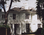
Barnsbury Square and go round clockwise
This has a mixture of buildings including Mountford House of
1834 which occupies the site of a moated farm. In the late 19th
century it was a home for desitute boys. Mountford Crescent in
the NW corner has paired villas of 1837-47 (pictured in header).
Left along Thornhill Road
Thornhill Houses of 1902 were built by the East End Dwellings
Company.
Left at Belitha Villas. Cross
Hemingford Road and continue along Huntingdon Street. Left into
Crescent Street.
There is a small nature reserve (Barnsbury Wood) on the
left.
Right around Thornhill
Crescent
St Andrew's Church was designed by Francis B Newman and John
Johnson in 1852-4. The attractive West Library was designed by
Beresford Pite in 1905-7 and financed by Andrew Carnegie. [pix]
Left at Bridgeman Road
To the right is Thornhill Square (begun in 1847). The
gardens were donated to the public by Captain Thornhill in 1946.
They retain the original railings.
Right at Hemingford Road then
left along Ripplevale Grove
The Grove has pretty cottages of 1839-41.
Go right along Thornhill Road
Th Albion pub on the left originated as a teahouse surrounded by
the dairy and fields of Thomas Albion Oldfied where cricket was
played between the 1780s & 1834. On the right is the
attractive Malvern Terrace (1836). the park on the corner was
formerly a nursery. At the end of the road are two old shops with
wall advertisements. [pix]
Go right along Richmond Avenue
Some of the houses here have Greek & Egyptian details
including sphinxes and obelisks. Richmond Crescent on the right
was the former home of Tony Blair.
Left into Hemingford Road. At
the end go left into Barnard Park.
This was formerly an area of housing. The cobbled road of
Alma Grove is visable on the left.
Walk through and exit into
Barnsbury Road then go right. Left at Copenhagen Street then
right at Cloudsley Road.
On the right is a small park with an entrance to the
Culpeper Community Garden. [website]
Cross Tolpuddle Street and
walk ahead through the Sainsbury car park into Chapel Market and
go left.
There are plenty of places for refreshments with good value
cafes.
At the end go right along Liverpool Road back to the Angel station.
© london-footprints.co.uk 2010
Resources
Buildings of England London 4: North by Cherry & Pevsner
A booklet has been written on Barnsbury by Mary Cosh for the
Islington Archaeology & History Society
The London Parks & Gardens Trust has produced a walk around
Islington's Green spaces [click here]
A Barnsbury Local History Trail has been produced by Islington
Library Service
Alan Godfrey OS map reprint No 39 Highbury & Islington 1871 [website]
[gallery] [New River walk] [walks list]