Route & what to see
![]()
|
A West Greenwich Walk Route & what to see |
|
london-footprints.co.uk |
A 3 mile walk from Greenwich Station (DLR & National Rail) to Cutty Sark DLR Station. There are plenty of places for refreshments and things to do in Greenwich to make a day of it.
Exit into Greenwich High Road,
cross and go left
Note the former Cigar Warehouse alongside the pub. Queen
Elizabeth College was founded in 1574 and rebuilt by the Drapers
Company in 1817.
Go around this into Greenwich
South Street then first left at Circus Street
The houses in Brand Street to the right were built in the 1830s
by George Smith for Morden College. The small house at number 26
contrasts with the large double fronted one at number 15. There
is an inscription 'Royal Circus Tea Warehouse' on number 12.
Further along is a former meeting room. The railway line to
Greenwich Park ran just beyond this.
Cross Royal Hill, noticing
small shops to the left. Walk through Gloucester Circus ahead,
keeping right of the central garden.
This was designed by Michael Searles in 1791-1809. The opposite
side was built as a terrace 30 years later but much of it had to
be rebuilt after WWII bomb damage.
Exit into Crooms Hill and go
right.
Crooms Hill Grove to the right has houses of 1838.
Right along King George Street.
There are a mixture of buildings in this road. Notice the
cars in the basements of the new houses! Number 69 is a former
pub and beyond this is the entrance to Greenwich Park School
(view of this further along). Look at houses in Georgette Place
and Luton Place (both cul-de-sacs) to the left. Between these The
Hall was built in 1816 as a Methodist Chapel and the adjoining
small hall dates from 1879.
Right at Royal Place
Old stables of 61 Royal Hill have been converted into cottages
accessed from this street.
Go left along Royal Hill.
This road has a mixture of houses, shops and pubs.
Left into Point Hill
The Hill was the Barley Mow pub with attractive tilework.
Opposite is a former hay and coal merchants premises
(inscription).
Left at King George Street
then right along Hyde Vale
There are attractive houses of the 1840s. Over number 14 is
an inscription 'Hamilton Terrace'.
Opposite number 67 go right
into Diamond Terrace. Follow this round to the right then
continue ahead.
There are views of the Borough Hall, Canary Wharf and St
Alfege's Church to the right.
Left at Point Hill then second
right along Maidenstone Hill.
There is a plaque 'College Place East' above number 17. Number
35 (built 1799) was the estate office for Morden College to whom
neighbouring properties of the 1840s belong. The oddly shaped
number 37 is part of 'College Place West'.
Between these go along the
path and continue up the shallow steps. Go up the steeper steps
to the left onto the Point.
This gives views over New Cross, Deptford and Greenwich to London
and Docklands. A board shows some highlights. Underneath are the
Blackheath Caverns, former chalk mines, finally closed in 1946
after serving as a tourist attraction in the first half of the
19th century.
Walk away from the viewpoint
bearing right across the open ground. Left down Point Hill then
right at Westgrove Lane. Left along West Grove.
There was a conduit head of 1710 on the corner (plaque).
Go up the steps opposite
Across the heath is the Ranger's House. The central portion is
from 1700 with later wings added. It is managed by English
Heritage and houses the Werner Collection (limited opening).
Left along Cade Road.
Further along on the right is MacCartney House, a home of General
Wolfe, altered by Sir John Soane in 1802 and now converted into
flats.
Continue down Crooms Hill.
There are notable houses such as the White House (c1690), Manor
House of 1695 (built for Admiral Sir Robert Robinson), Park Hall
(1723) by John James and Hillside (1723 altered 1799). The RC
church of Our Lady Star of the Sea, designed by William Wardell
in 1851, has a tall spire and furnishings by Pugin. Heathgate
House, formerly the presbytery, dates back to 1635. Mays
Buildings of 1774 were built on part of The Grange gardens. The
Grange is an attractive house of 1801 with a gazebo by Robert
Hooke (1672).
Opposite this go into the park
There is an 18th century Standard House to the right
attributed to Hawksmoor.
Walk down the path running
parallel to the road and exit at the next gate. Continue down
Crooms Hill.
The Fan Museum occupies an attractive house at number 12.
Opposite is the modern front of Greenwich Theatre which was
converted from an old music hall in 1969. Detour into Nevada
Street to view the retained 1885 facade. The corner restaurant
was a former coaching inn the 'Spread Eagle' whose yard entrance
remains.
Cross Stockwell Street into
Burney Street.
The Borough Hall was designed by Clifford Culpin in 1939.
Since 1964 Greenwich has been managed from premises in Woolwich.
On the corner is a plaque to: Doug Mullins 1932-91 Master
Dairyman born over shop on this site.
Right along Royal Hill and
right at Greenwich High Road
Around the paved area before the cinema is masonry from the
Workshop for the Blind.
Cross towards the Mitre pub
then go along Roan Street. Walk through to the west end of the
church
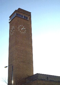
The present St Alfege's Church was designed by Nicholas Hawksmoor
in 1714 with a tower of 1730 by John James [pix]. The church hall (built 1814 but
extended) was the Greenwich National School of Education and
Industry for Girls.
Alongside this go into the
former churchyard and follow paths to the right.
Some of the graves have been cleared to provide sports
facilities. A old mortuary building is visable in the corner.
Exit into Bardsley Lane and go
right
In the cul-de-sac at the end are the former Coroner's Court
(1902) and Weights & Measures Office (1900).
Continue into Creek Road for access to the station.
Resources
Discover Greenwich and Charlton by Darrell Spurgeon
© london-footprints.co.uk 2012
[Hawksmoor Churches] [places to visit] [cheap day out] [walks list]