Route & what to see
![]()
|
A Wandsworth Walk Route & what to see |
|
london-footprints.co.uk |
A walk of 4½ - 6½ miles from Clapham Junction Station including some of the Wandle Trail.
Exit the station via the
shopping centre into St John's Hill
Opposite is the aptly named Grand opened by Dan Leno in 1900 [more info].
Go right along St John's Hill
The building on the right has the inscription 'London Brighton
& South Coast Railway - Parcels Office'. The Peabody estate
to the left occupies the site of the Royal Masonic Institute for
Girls. On the corner building of Sangora Road is an old advert
for Peterkin Custard. Further along on the right is the former
Grammar School of 1909. Behind the St John's Therapy Centre are
buildings of the Union Workhouse [more info]. John Morris House serves as a community
centre.
Continue along East Hill
Just past the workhouse were the Fishmonger's Almhouses built in
1849-51 for 42 almspeople with a chapel, hall and library. As St
Peter's Hospital these had been established in Newington in 1618.
In 1923 the site was sold to the LCC who replaced the buildings
with flats, retaining the entrance arch. To the left in Spanish
Road was the Victorian 'Friendless Boys Home'. The road crosses
the approach road to Wandsworth Bridge giving a view of the
structure on the roundabout (and in the distance the Wembley
arch). Further along on the left is the Huguenot Burial Ground
(entrance on the east side) opened in 1687 and closed in 1854.
The Huguenots fled persecution in 17th century France and set up
businesses in the area which made Wandsworth prosperous. The
building on the corner (now Book House) was the Board of Works
office of 1888.
Cross and go along Geraldine
Road by the United Reform Church. Take second right along
Rosehill Road and cross St Ann's Crescent to the church
taking the path alongside to the front.
St Anne's Church, designed by Robert Smirke, was the fifth of the
Waterloo churches. Known as the 'Pepper Pot' it was built as a
chapel of ease in 1824 becoming a parish church in 1850. The
burial ground was never consecrated. A chancel was added by
Edward Mountford in 1896. The church was damaged by a flying bomb
in 1944 and restored in 1947 and again in 1950 after a fire.
Go right at St Ann's Hill
On the right is St Anne's C of E School
Left into Wandsworth High
Street
The South Thames College was built in 1922-3 replacing the
Wandsworth Technical Institute of 1895. This building had been
built on the site of an ice skating rink. Opposite is the town
hall designed by Edward A Hunt which replaced the earlier
building of 1882. Adjacent is the Civic Suite and former Palais
Theatre, opened as a cinema in 1920. On the left the Quaker
Meeting House was built in 1778 and refronted in 1927. The Spread
Eagle existed as a coaching inn in 1780 and was rebuilt in 1898
(Grade II listed).
Left into Garratt Lane
The former court house of 1860 now houses Wandsworth Library.
Further along the old burial ground has been laid out as park
Beyond Waitrose cross Garratt
Lane and take the brick path running alongside the river,
crossing two bridges. Continue along the path into King George's
Park.
The park was opened by George V in 1923.
For a longer walk including
more of the Wandle Trail go to the left then up the slope
following the river to the left. Cross Kimber Road and continue
to the sports centre. Go to the right along the roadway beside
this then right at Burr Road. At the end cross and go back into
the park alongside the 'East' building. Follow the paved path
through then bear right at the Mapleton Road exit. At the toilet
go left.
There are rose beds, bowling green and a lake to the right and
tennis courts, picnic area and playground to the left.
For a shorter walk take the
path to the right towards the playground. At the toilet go right.
There are rose beds, bowling green and a lake to the right and
tennis courts, picnic area and playground to the left.
Past the One O'Clock club bear
right then left. Exit into Buckhold Road and go right
The baths on the High Street were demolished for the construction
of this road.
Cross the High Street and go
into Wandsworth Plain
Church Row on the right has 18th century houses built for
prosperous merchants. At the end of this street was the Middle
Mill, which in the 16th century produced a scarlet dye for which
Wandsworth became famous. Here also was the Blackmore Bolting
Cloth Factory (1814-1919).
Cross Armoury Way
This was constructed in 1935-8 after the clearance of houses, a
cattle pound and The Bells pub.
Go right towards the Crane pub
This 18th century pub was rebuilt in the 1920s. In Dormay
Street is Wentworth House, home to the Wentworth family who made
beam engines in the 19th century.
Continue along the Causeway
There are sluice gates with a bell which rang at high tides. A
board walk has been constructed alongside the river further
along. The Lower Mill was sited near here.
Go under the railway then
through the gate onto the Spit.
This has been laid out as a nature area and gives views of the
mouth of the River Wandle. There is a waste transfer station to
the right (Feathers Wharf).
Return and take the bridge
over Bell Lane Creek. Go through the industrial estate then bear
left into Osiers Road
At the end in a cul-de-Sac are Prospect Cottages. These would
have been the homes of labourers who worked in the wharves.
Go right along Point Pleasant
This has new buildings but the old Cat's Back, a former
lighterman's pub, remains. Further along on the left the Regency
villa Prospect House has been restored.
Head towards the river
New development has replaced the Union Brewery and later
gasworks.
Go along to the left into
Wandsworth Park.
Hurlingham House is sited across the river. Wandsworth Park
(Grade II listed) was designed by Lt Col J Saxby (superintendant
of parks) and opened in 1903 with playing fields and a planted
corner in the south east. The 18 acre site which had been market
gardens was purchased in 1898. In the 1920s a bowling green and
tennis courts were added.
There is the option of
exploring the park before exiting at the south east corner. Go
under the railway along Putney Bridge Road. Cross and go right
into Oakhill Road by the Queen Adelaide pub
There is a school on the left and some attractive cottages in
Oakhill Place to the right
First left along Santos Road
At the end is the RC church of St Thomas of Canterbury. This was
built in 1895 and the tower added in 1920. Across the road
junction is the fire station, built in 1955 to replace the
building of 1892 destroyed by bombing.
Continue along West Hill
The former library houses the Wandsworth Museum and De Morgan
collection. The police station of 1883 stands on the site of
Sword House, demolished in 1870. Just past this some old houses
remain at numbers 140-2.
Continue along Wandsworth High
Street
Child Tailors have an attractive shop at number 106. The main
part of All Saints Church was built in 1779-80 by William Jupp
retaining a tower of 1630. It was altered in 1841 and an apse was
added in 1899. There would have been a lock-up and stocks
alongside at one time. The churchyard was last used in 1854 and
subsequently cleared. The church was rebuilt in 1955 following
WWII bomb damage. The site on the left just before the bridge was
that of the Bull pub, rebuilt in the 1890s but destroyed by
bombing in 1944. Queen Elizabeth I ordered the bridge over the
Wandle to be repaired in 1602. It was widened in 1757, 1820 and
1912. A brewery was set up in 1675 and Youngs used the site from
1831 to 2006. It is due for redevelopment by Minerva. Opposite
Southside Shopping Centre includes shops & restaurants, a
multiplex cinema and fitness centre. The River Wandle flows
beneath the complex which stands on the site of the Upper (flour)
Mill, operational until a fire in the 1920s and demolished in
1962. In 1933 a Greyhound Stadium seating 20,000 people also
occupied the site
Go left into Ram Street
On the left are former brewery buildings. On the wall further
along is a plaque recording the site of the Surrey Iron Railway,
a track for wagons opened in 1803.
Go right along Barchard Street
There are some attractive cottages along this street which
includes Victoria Place of 1839. It is named after a Huguenot
dyer but was formerly Red Lion Street (until 1909).
Go right at Fairfield Street
There are town hall buildings on the right with friezes depicting
the town's history. The coat of arms includes tear droplets to
represent the sorrow of the Huguenots.
Go left along East Hill.
On the corner is a former pond and a plaque recording the
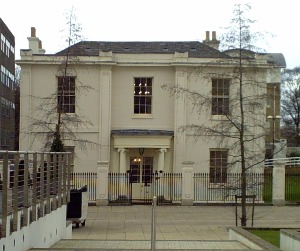
opening of the town hall by Queen Mary in 1937. Wandsworth House
is a fine listed Georgian house with outbuildings.
A little further along buses return to Clapham Junction station or you can retrace the route via St John's Hill. For an alternative return route (about 1 mile) take Huguenot Place, Wandsworth Common North Side, Battersea Rise then go left at St John's Road.
© london-footprints.co.uk 2010
[trails] [walks list]