Route & what to see
![]()
|
A Wandle Sources Walk Route & what to see |
|
london-footprints.co.uk |
A 4-5 mile walk along the upper
reaches of the River Wandle including its two main sources. The
walk begins at Wandle Park tramstop or Waddon Station and
finishes at Carshalton. Sections of the walk can become muddy.
Note: (RL) = river on left & (RR) = river on right as you
walk. Look out for Kingfishers!
From Wandle Park tramstop go down Vicarage Road and cross Waddon Road into Benson Road. Continue along Waddon Park Avenue. Cross the Purley Way and go right at Waddon Court Road then enter the park on the left.
From Waddon Station go right along the Purley Way for a short distance. Left into Waddon Court Road then enter the park on the left.
Follow the path to the right
(RL)
This spring-fed pond is one of the main sources of the River
Wandle.
Exit into Mill Lane and go
left
A corn mill was recorded in the Domesday Book. Its last
replacement closed in 1928. The northern pond was filled in in
1964.
Continue on the footpath -
not the works access (RR) then along the road ahead (Bridle
Path). Bear right into Bridges Lane
Beddington Mill of the 1890's replaced an earlier timber
building. There is an adjoining mill house with outbuildings.
Bear left along Wandle Bank (RR)
The riverside cottages (Mount Pleasant) housed mill workers.
Cross Hilliers Lane and go
around Guy Road (RR) then second right into Church Lane which
continues as a footpath into Beddington Park. Go right at the end
of the churchyard wall (Church Road).
The Domesday Book records a church here but the present building
dates mainly from the 14th century with later additions. The
cemetery gate opposite has been restored. Carew Manor was
occupied by the family from the mid 14th century until 1859 when
it was sold to pay gambling debts. Largely rebuilt it became an
orphanage (1866-1939) but is now a school. The Great Hall with a
hammer beam roof of 1500 remains (Grade I listed).
Continue to the East Lodge
ahead
This was commissioned in 1877 by Canon Bridges, Rector of
Beddington. He acquired the park in 1859.
Go to the right past a
dovecote and some cottages.
The Dovecote was built between 1715 & 1720 to replace an
earlier building and contains 1360 nesting holes. The end cottage
has a timber framed wall.
Cross the river and follow
it to the left (RL).
On the left is Canon Bridges' Bridge, made in Torquay. There
are toilets in the pavilion building off to the right.
Continue to follow the river
(RL) passing, but not crossing, a flint bridge then a metal
bridge. Opposite this go right along the conifer path then bear
left towards a sunken pond. Go up the steps and along the pergola
walk.
The original Grange of 1880
burnt down in 1960. The
present building is now a restaurant.
Take the riverside path to
the left (RL) out into London Road
Opposite is Bridge House, built 1782-6 for James Newton, proprietor of
Merton Abbey Mills. It has been restored to serve as a care home.
Go left along London Road
On the right is the early 18thc Wandle Bank which was the
home of the Pre-Raphaelite painter Arthur Hughes from 1876-91.
Go around the roadside pond
then cross the road.
The Elms Pond has been re-instated
Go to the right of the
Londis Store and Rose & Crown pub into Butter Hill. Follow
this road round and at the end turn right into Mill Lane. Just
beyond the railway bridge on the right is the entrance to
Wilderness Island.
This Nature Reserve is managed by the London Wildlife Trust.
Paths and a numbered trail lead to the confluence of the two
branches of the River Wandle [more info]. Strawberry Lodge which was built for
the gunpowder maker Josias Dewye is now a Conference Centre.
Retrace your steps back down
Mill Lane. Just beyond Butter Hill follow the path & cycleway
alongside the river (RR).
This was the site of Ansell's snuff mill, traces of which
can still be seen. A fish ladder has been installed.
Ignore the first bridge but
cross the second (at Oakham Road) and continue along the path
(RL). At the end enter The Grove (Park) and walk to the right
(RR) then onto the bridge at the cascade.
This was rebuilt in 1968 on the site of an old weir which
provided a head of water for the mill.
Continue to the mill
building.
There has been a mill here since the Middle Ages which originally
ground corn. It was rebuilt in 1783 to the designs of John
Smeaton. A steam engine was installed in 1854 to provide power
when the river was low and increase the number of stones to 10
pairs. Aurelia Cator purchased the mill in 1887 and replaced it
with an Alpine style building housing a water-powered electric
generator to serve The Grove and Stone Court. About 1909 the
water wheel was replaced by a water driven turbine which was in
use until about 1923. The mill was restored in the 1980s but the
present building was constructed following a fire in 1984.
Go left and exit into Mill
Lane
Stone Court is used by Sutton Council
Go along West Street Lane
opposite and at the end left along West Street.
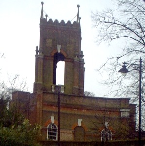
There are some attractive cottages here. On the right is the
Carshalton Water Tower (pictured in header). This Grade II listed
early 18th century garden building is sited in the grounds of
Carshalton House (now a school). It contained a water-powered
pump, which supplied Carshalton House and the fountains in its
garden. The building also contains a suite of rooms with a
Saloon, Orangery and a splendid early 18th century bathroom with
tile lined plunge bath.
Left along Festival Walk
There is a view of the rear of Honeywood to the right and one of
London Great Trees. On the left is the Old Rectory (1690-1710)
and the Sutton Ecology Centre. There is a numbered trail around
the varied gardens and habitats and a programme of family events.
Overlooking the pond is Honeywood which houses a local museum and
cafe. Parts of the building are 17th century with Victorian and
Edwardian additions. The ponds are the second main source of the
River Wandle.
Continue along Honeywood
Walk
On the right is the war memorial and across the pond is a view of
the Greyhound pub (rebuilt 1840) and the parish church of All
Saints. This was mentioned in the Domesday Book but extended
1890-1913.
Cross North Street with care
and go through an opening in the wall to the left. Follow the
footpath to the right (passing the second pond).
The Grove was built in 1840 and leased to the rector W A B Cator
in 1856. The building with an overhanging upper story is the
Apple Store. Outbuildings including stables now house a nursery.
Exit through the car park
into the High Street
Some notable buildings have Sutton Heritage plaques.
Buses return to Croydon.
© london-footprints.co.uk 2016
Resources
The Wandle Trail (PDF map) [click here]
River Wandle Companion by Bob Steel [webpage]
Wandle Valley Regional Park [website]
Wandle Industrial Museum [website]
Wilderness Island [webpage]
Village London (Carshalton) by Andrew Duncan
Heritage walk around Carshalton [click here]
Sutton Heritage [webpage]
Photobox album [webpage]
[places to visit] [walks list]
![]()