A Surbiton & Thames Ditton Walk
Route & what to see
|
|
| london-footprints.co.uk |
A 3¼ mile circular walk around Surbiton with a 3 mile extension to Thames Ditton. Surbiton is 'leafy suburbia' with a number of conservation areas. Many buildings date from its periods of growth with the arrival of the railway and the inter-war years.
Exit
Surbiton Station on the Victoria Road side and go left along this
road
The railway located to its present site in 1838. The current
station building was designed by J Robb Scott in 1937. Early
houses in Victoria Road were converted to commercial use around
1870. The station and properties opposite are listed buildings.
Further along a former post office of 1898 is now Zizzi. There
are transport murals on the Sainsbury store.
Left into
Upper Brighton Road, right at Lovelace Road then left along
Corkran Road.
This area has large detached houses from the 1860s to 1930s.
Right at
Woodlands Road then left along Ashcombe Avenue.
Southborough House is a Grade II listed building of 1808
designed by John Nash. [webpage]
Left along
Langley Avenue. At the junction cross and go right along
Kingsdowne Road.
At the end is St Matthews Church.
Left at
Ewell Road.
There are five late 19th century detached villas
in Gothic style on the left.
Enter
Fishponds Park on the right
This has mature trees, ponds, streams and steep banks with
dense hedging along the boundaries. The area was used for the
extraction of brick earth and the manufacture of bricks.
Follow the
path bearing left past a pond and towards the house.
The original mid 18th century house was much
altered in the 19th century.
Continue
along the tarmac path to the left exiting into Mayberry Place
The terraced artisans cottages were built on former
brickfields in the late 19th century.
Left at
Browns Road then right into Ewell Road.
Bank Buildings of 1904 are opposite.
Detour
into Langley Road
Surbiton New Life Church and Gothic house opposite.
Return to
and go left along Ewell Road
Entrance to former Berryland Dairy (1840). The Surbiton
Hospital site has been redeveloped to provide new healthcare
facilities and a school. Methodist Church and former school.
Beyond this are civic buildings from the inter-war years; fire
station (1931), library halls with war memorial, library, Crown
Court and Telephone Exchange. Behind the war memorial is a cairn
made of stones from St Mark's Church, bombed in October 1940.
Opposite
the fire station detour into South Bank to view Hillcroft
College.
This was built as The Gables for Wilberforce Bryant (of
Bryant & May matches) in 1884.
Return and
after crossing the railway continue down Surbiton Hill Road (on
the right hand side).
St Mark's Church, visable to the left, was destroyed in WWII
except for the tower and rebuilt in 1960. Hollyfield School
occupies attractive buildings. Hexagon House is used by the
Freemasons. At the road junction the former assembly rooms are
now part of Surbiton High School. They were designed in 1882 by A
Mason.
Left along Maple Road.
Claremont Hall is now used as a nursery.
Left along
Claremont Road.
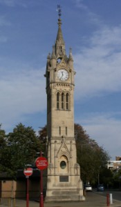
This area with The Cresent and its gardens was developed
from 1838. At the end of the gardens is the listed Clock Tower of
1905-8 which commemorates the coronation of Edward VII in 1902.
The buildings on the left have fine terracotta decoration.
Detour
left into St Mark's Hill
The Coronation Hall, opened in June 1911 as a lecture hall
was later a cinema then used for bingo. It is now a Wetherspoons
pub.
Cross to
the station or to continue the walk go along St James' Road
opposite this.
The Surbiton Club. Claremont Cottage Hospital opened in
1883. It was replaced by the WW1 Memorial Hospital in Ewell Road
but this was not opened until 1936. The Claremont buildings
remained in medical use until 1977 but have now been converted to
apartments.
Left along
Maple Road.
This area was developed in the 1860s-1880s in Gothic and
Italianate styles. St Andrews Church was designed by A W
Blomfield in 1871. The garden square is unique to SW London.
Right at
Brighton Road
Notice the cottages in Seething Wells Lane.
Left along
Portsmouth Road.
The waterworks moved upstream from Chelsea in 1856. On the
left the buildings have been converted to health and residental
use. On the right are the remains of filter beds and the current
Thames Water premises [wikipedia
article]. Beyond these
is the Thames Marina.
Right at
Ditton Reach then go left through the grass area. Left at Ferry
Road.
Stoneleigh House was once the police station and is said to
retain its cell block.
Continue
along Portsmouth Road to the right then right at Giggs Hill Road
alongside the green.
St Leonards Cottages were formed from a former late 18th
century stable block.
Right at
Watts Road.
The clinic and library are modern buildings. Further along
is Cooper Hall & Cottage (left) and Byways and Rose Cottage
(right).
Continue
along the High Street.
The old slaughterhouse dates back to c1580 and was used by
the Royal deer catcher 1860-1921. This and the home of Cesear
Picton have plaques. Picton (a black boy) was brought from
Senegal and presented to Sir John Philips. A legacy enabled him
to set up in business as a coal merchant in Kingston. He retired
to Thames Ditton and died in 1836 aged 81. The Home of Compassion
consists of a main house (built as Boyle Farm in 1792), a former
chapel and a priory. The premises are being redeveloped as a
private care home.
Continue
along Summer Road
Ye Olde Swan pub was formed from two houses, linked and extended.
Alongside is a footbridge to Thames Ditton Island (no public
access). Ferry Works are now industrial units but were occupied
by AC Cars 1911-29. A former foundry opposite operated until the
1970s and produced famous pieces including the Peace Quadriga on
Wellington arch.
Return and
take the path to the church.
Parts of St Nicholas date back to the Norman period but
there are many additions and alterations. It is usually open to
visitors and a guide book is available. [website]
Continue along Church Walk then detour right into Speer Road to view the former school.
Take Speer
Road southwards.
The United Reformed Church is in an unusual style.
Detour
left into Station Road to view Henry Bridges almshouses.
These 6 one bedroom cottages were built in 1720 and restored in
1925 and 1977 (see plaques).
Return and
cross into Embercourt Road
The Vera Fletcher Hall was built in 1887 to commemorate
Queen Victoria's Golden Jubilee. It was saved from demolition to
provide community facilities including a theatre. [website]
Return to the crossroads to access Thames Ditton Station.
Resources
Conservation area documents for Surbiton [click here] Areas: 3, 4, 8, 10, 19, 26 are
relevant. Page 5 has a map and photos.
Conservation area studies for Surbiton [click here] Select area on left for further
documents including OS maps.
Claremont Hospital [webpage]
Conservation area map of Thames Ditton [click here]
Listed Buildings in Thames Ditton [webpage]
Photographs of Thames Ditton [webpage]
Thames Ditton [pix]
Thames Ditton plaques [webpage]
© london-footprints.co.uk 2015