Route & what to see
![]()
|
A Maritime Greenwich Walk Route & what to see |
|
london-footprints.co.uk |
A 2¼ mile circular walk from Cutty Sark DLR Station which includes opportunities for visits. Alternatively the walk can be combined with my West Greenwich route [click here].
Exit the station to the left
into Greenwich Church Street and go left to Cutty Sark Gardens.
The domed brick structure is the entrance to the Greenwich Foot
Tunnel under the Thames to Island Gardens. The Cutty Sark ship,
the last of the tea clippers, is open to the public (charge).
Boat trips upstream to central London and downstream to Woolwich
are available from the pier.
Follow signs to the
information centre
This building also houses Discover Greenwich, bar and shop.
Take the riverside path
eastwards.
There is a memorial to Bellot who died whilst searching for lost
explorer Franklin. The path, known as five foot walk, goes past
the King Charles and Queen Anne blocks of the Old Royal Naval
College and Grand Square with a view of the Queen's House. At the
end of the path is the Trafalgar Tavern. This building of 1837
re-opened as a pub in 1965 having served other uses for some 50
years.
Take Crane Street between the
pub and the Trident Hall.
This passes another riverside pub, the Yacht. Further along is
the attractive Trinity Hospital (almshouses) founded in 1613 but
rebuilt in 1812. Next door is the Greenwich Power Station and its
coal jetty. Built by the LCC in 1906 for the trams it later
provided peak power for London Underground.
Continue along the riverside
path, known as Ballast Quay.
Beyond a new development is the Cutty Sark pub of 1804 and some
old houses including that of the Harbour Master.
Just beyond this turn right,
away from the river, into Pelton Road.
On the left was Lovell's Wharf.
Go right into Banning Street
and left into Caradoc Street. At the bend go right through to
Braddyll Street then left to Woolwich Road.
These houses form the East Greenwich Estate designed by George
Smith in 1842-69 for Morden College (note property mark).
Go right along Old Woolwich
Road.
Beyond Hoskins Street is the Trenchard Estate of 1913 on the left
and the power station on the right. Trinity Hospital has some new
buildings and an entrance to its garden from this road. Opposite
is the Meridian School of 1888, which with the hospital lays on
the meridian line. Beyond Eastney Street on the left is a former
pub 'The Man in the Moon'.
At the end go right into Park
Row.
On the right are Trafalgar Quarters built in 1813 as lodgings for
officers at the Naval College.
Go through the East Gate
opposite this building and continue ahead through the College
grounds.
On the right is the Queen Anne block and on the left the Queen
Mary block which includes the Chapel (open to visitors). At the
Grand Square is a statue of George II and a view to the Queen's
House and Greenwich Observatory. Beyond the square on the right
is the King Charles block (occupied by Trinity College of Music)
and on the left the King William block which includes the Painted
Hall (open to visitors).
Continue along the central
path.
On the right is an area where TV's Time Team carried out a search
for evidence of Greenwich Palace.
Take the path to the left
(signposted Maritime Museum etc)
On the right is the former Dreadnought Seaman's Hospital which
now houses the University of Greenwich library.
Cross Romney Road and go into
the grounds of the Maritime Museum to the left.
There is lots to see in the museum which offers free admission.
Take the path across to the
Queen's House.
This was built by Inigo Jones in 1617-35. It is now part of the
Maritime Museum (free admission). Closed July 2015 - 2016
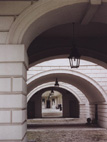
Go up to the colonnade to the
left of the house and walk back under the house towards the
museum.
This undercroft (pictured in header) is a favourite with
filmmakers. The line of the colonnade is where the Woolwich to
Deptford road ran before Romney Road was constructed.
Go left to the park side of
the museum.
The new Sammy Ofer wing opened in 2011 and now provides the
entrance to the museum.
Take the path towards the park
gate.
This passes the site of St Mary's Church demolished in 1936.
There is a statue of William IV (the Sailor King).
Exit the park and go right
along King William Walk.
On the right is the entrance to the Devonport Conference Centre,
the Students Union (Cooper Building) and student accommodation.
Cross Romney Road at the
lights to the right then King William Walk to the left. Go down
Turnpin Lane.
This leads into Greenwich Market where there are shops and often
stalls.
Walk to the right through the
market.
Notice the inscription above the entrance!
Exit into College Approach and
go to the left back to the station.
© london-footprints.co.uk 2015
Resources
Discover Greenwich and Charlton by Darrell Spurgeon
Greenwich Heritage Centre is now located at Woolwich Arsenal
(building 41)
[places to visit] [cheap day out] [Meridian] [almshouses] [sundials] [walks list]