Route & what to see
![]()
|
London Wall Walk Route & what to see |
|
london-footprints.co.uk |
A number of fragments of the defensive wall, originally built by the Romans around Londinium, still exist and can be viewed by tracing the line of the wall. In 1984 the Museum of London set up the London Wall Walk with 21 tiled panels (not all remain). The booklet they produced in conjunction with this is no longer available but a map can be downloaded from the website in PDF format [click here]. A 3 mile walk following the wall from Tower Hill to Blackfriars is detailed below. A series of photos can be viewed on flickr
INTRODUCTION
Londinium was founded in AD43 when the Romans invaded Britain but
was destroyed by Queen Boudica in AD60. It was rebuilt as a city
from AD70 to include a forum & basilica, a palace and an
amphitheatre & fort to the north west by AD125. When the wall
was built around AD200 this fort was incorporated. The wall, of
about 2 miles, was 6m high with gateways at road intersections.
It was built of Kentish Ragstone, brought by boat along the
Medway and Thames, with bands of red tiles. A wall along the
river was added, along with towers in the eastern section, in the
4th century. The Saxons who followed lived outside the walls in
the Aldwych area but in the Medieval period people moved back and
rebuilt the walls for defence. From the 17th century as London
grew the walls were incorporated into buildings or used to
provide materials.
The following information is correct at June 2010
PANEL 1 is at the underpass between Tower Hill tube station and the Tower of London. There is an introductory panel as well as one (metal replacement) at the remains of a Medieval postern gate.
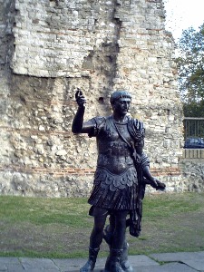
PANEL 2 is in the garden area by Tower Hill tube station (entrance section) where there is a large section of Roman wall topped with later Medieval stonework. Also there is a statue thought to be of Trajan and a copy of a tombstone to Julius Classicianus found nearby.
DIVERSION to the large sundial outside the station which depicts the history of London - look for Maggie Thatcher!
PANEL 3 new metal panels on the hotel building. View the wall section from the courtyard, accessed from the east side of Coopers Row.
PANEL 4 on the west side of Vine Street with the actual remains visable through glass panels in the adjacent yard.
There are remains in the Guildhall University building but there is no public access to these.
PANEL 5 at Aldgate is on the wall of the John Cass School
DIVERSION to the first of 3 churches dedicated to St Botolph, a patron saint of travellers and hence their siting at city gates.
DIVERSION to the remains of Holy Trinity Priory which can be seen in the basement of the Towergate building.
PANEL 6 is located in the subway by exit 1 where a cross section of the Roman wall is depicted in tilework
PANEL 7 is on the south side of Bevis Marks by the Synagogue
DIVERSION into the Synagogue which is open to visitors 10:30 - 2 Mon, Wed & Thu and 10:30 - 1 Tue & Fri (charge)
PANEL 8 and the wall it was attached to were destroyed by an IRA bomb in 1993. The site of the Bishopsgate is however marked by bishop's mitres on buildings either side of the road. Most gates were taken down in 1760-1 as they were a hinderance to traffic. The Roman Ermine Street to York went through this gateway and cemeteries were sited outside.
PANEL 9 was located in Bishopsgate Churchyard. The wall was incorporated into buildings in Wormwood Street.
DIVERSION to the church of St Botolph (often open)
PANEL 10 has gone from the piece of ground alongside All Hallows-on-the-Wall where the Medieval section was used in the churchyard wall. The Roman portion is below ground level but the church vestry was built on the foundations of its tower.
PANEL 11 at Moorgate is at the NE corner. East of here the wall was utilised in the boundary wall of Bethlehem Hospital for the insane. Moorgate was not in the Roman wall but was a later addition.
DIVERSION to the remains of the Roman Amphitheatre found at Guildhall and located within the Guildhall Art Gallery. Open 10-5 Mon - Sat & 12-4 Sun. Admission free. Tel 020 7332 3700. The extent of the arena is marked in the paving of Guildhall Yard. Remains of the SE corner of the fort were found in Aldermanbury outside the library.
PANEL 12 was in St Alphage's Gardens. This large section of wall is also visible from the Highwalk and Fore Street where it is within the premises of the Salters Livery Company.
PANEL 13 is at the corner of Wood Street and St Alphage's Garden. This was the site of Cripplegate, the north entrance to the fort.
PANEL 14 and the section of wall to which it relates can be viewed from the south side of St Giles Church along with the corner tower (15)
PANELS 15, 16 & 17 relate to sections which can be viewed from the gardens by the Barbers Hall (access through Monkwell Square or from London Wall). These are towers added in the Medieval period. Only Panel 15 still exists and is quite tucked away. Section 17 can also be seen from the Museum of London's viewing gallery.
PANEL 18 is by the entrance to the car park under London Wall. This section which is the west gateway of the Roman fort can be viewed by arrangement with the Museum of London who organise occasional openings.
PANELS 19 & 20 were on the west side of Noble Street but disappeared during construction work. They have been replaced by a series of etched glass panels.
PANEL 21 at Aldersgate is on the east side
DIVERSION to the Museum of London with Roman Gallery and shop. Open daily 10-6 (last admission 5:30). Admission free. Tel 020 7600 3699
There are no more tiled panels as the Museum of London wanted you to finish the walk by viewing their galleries but there are some more wall sites on the western section to Blackfriars
DIVERSION through Postman's Park. This former churchyard of St Botolphs has a shelter with tile memorials to ordinary people who undertook acts of bravery and self-sacrifice. A guide book is available at the Museum of London bookshop.
Angle Bastions of the wall were found on the site of the former Royal Mail King Edward Building. One of these was destroyed (by explosives) during the construction of the building in 1936 and used as hardcore in the yard. No public access.
SITE 22 is at the Merrill Lynch building occuping the corner site of Newgate & Giltspur Street. The line of the wall is marked in the passageway and courtyard paving and also with plaques. Remains can be seen in the entrance lobby. Contact security to arrange access to other parts. Tel 020 7628 1000.
SITE 23 is Newgate marked on the Central Criminal Court. This gate was once a notorious prison [Crime & Punishment walk]. There are sections of the wall within the Court but these are not accessible to the general public.
SITE 24 is Ludgate marked on St Martin's Church. The Roman wall ran directly south from here but in Medieval times it was rebuilt along the line of Pilgrim Street and to the east of present New Bridge Street to include the Blackfriars Monastery.
NOTE a number of Roman objects can also be seen in the British Museum
Resources
The Times London History Atlas
Londinium: a descriptive map & guide to Roman London
published by OS which shows Roman features including the wall
overlaid on a modern city map. Try Amazon for second hand copies
of this.
Walking London Wall by Ed Harris
Time Out London Walks Volume 2
© london-footprints.co.uk 2011
[places to visit] [booklist] [walks list]