A Kings Cross Regeneration Walk
Route & what to see
|
|
| london-footprints.co.uk |
A 2 mile walk looking at the regeneration of the Kings Cross area. Work is on-going so you may need to take diversions!
Begin at Kings Place on York
Way
York Way, formerly Maiden Lane, was an ancient route between
Islington and St Pancras. Kings Place, with a serpentine glass
frontage, was designed by Dixon Jones in 2008. Office space
finances the public facilities which include two galleries, a 420
seat concert hall plus a smaller hall. There is a large
foyer/atrium with cafe, a restaurant and access to the canalside
with pieces of public art throughout the complex. The Regent's
Canal was completed in 1820. Battlebridge, a hamlet by a bridge
over the River Fleet, gave its name to the canal basin.
South of Kings Place go
around Crinian Street
The buildings on the left belonged to Robert Porter's
bottling works of 1906 onwards and were redeveloped in 1988-9.
Left at Wharfdale Road
The artwork VERT (2013) by Neil Ayling features growing
plants.
Left at New Wharf Road
This has a mixture of new build and converted warehouses.
The London Canal Museum is housed in an ice warehouse built for
Carlo Gatti in the 1860s with two deep ice wells. The front of
the building was rebuilt in 1904-6 and first floor stabling
provided for horses. From 1926 it became warehousing and light
engineering works and during WWII a depot for spare parts for
London buses. The Museum Trust took on the building in 1989. The
area of water to the rear is Battlebridge Basin, constructed in
1820 and originally surrounded by saw mills, a bottling plant, a
jam factory and flour mill.
Right at All Saints Street.
To the left is Regent's Wharf with reconstructed grain mill
buildings and new offices in warehouse style. Further along a red
brick office building of the 1890s has a Baroque doorway. Across
the road at the end is the Thornhill Arms pub of the 1880s with
attractive tilework.
Right along the Caledonian
Road.
This road was laid out in 1826 and took its name from the
Royal Caledonian Asylum of 1827-8 for the children of poor exiled
Scots. The Driver gastro pub has planted walls and a roof
terrace.
Right along Wharfdale Road.
Left through Trematon Walk.
This is part of the Regents Quarter, a redevopment of former
industrial premises.
Cross Railway Street into
Albion Walk
This section of the Regents Quarter included iron, brass and
copper works. There are plaques in the pathway and a millstone in
the central courtyard.
Exit into Balfe Street to
the left. Go right along this street and cross Caledonian Road to
view Keystone Crescent
These buildings of c1845 lie on the boundary between Camden
and Islington boroughs.
Return to the Albion
Courtyard
Above the entrance is 'Works & Mills 1846'.
Go left to continue through
this section of buildings
To the left is a Tesco Metro store and to the right a Premier Inn
Cross Caledonia Street into
the third section of the Regents Quarter.
On the right of the entrance is a foundation stone of the
laundry buildings that originally occupied the site.
Exit to the left
There is a large artwork on the left hand wall.
‘King’s Cross Labyrinth’ was commissioned by P
& O Developments in 2004. The moulds were digitally designed
by Philip O'Reilly and created in Wales and all the tiles were
hand made by Philip at his studio in Peckham. The
mural’s narrative was based on local research in the area
and information gathered from English Heritage. The tiles
show images based on Barges, Trains, Signals, Parks, Plant life,
Novels, Films, Foundries etc, and other ideas associated with the
King’s Cross Area.
Right at Caledonian Road
The Scala was originally built as a cinema to the designs of
H Courtney Constantine but construction was interrupted by the
First World War and it spent some time being used to manufacture
aircraft parts, and as a labour exchange for demobilised troops
before opening in 1920 as the King's Cross Cinema. The
cinema changed hands and names several times through its life and
also changed focus, ranging from main-stream to art-house to
adult film over 70 years before becoming a night club. The
'Lighthouse' building (Grade II listed) was built around 1875. It
may have housed a clock tower, Victorian helter-skelter, or even
a camera obscura. Another explanation is that when oysters were a
cheap and popular fast food, Netten’s Oyster House was
marked with a lighthouse. After many years in a derelict state it
is being redeveloped for retail and office use.
Right along Pentonville
Road. Cross York Way and walk across the new public square
towards the main signposted entrance to the station
The Great Northern Railway built their London terminus
between 1849 & 1852. The 93 room Northern Hotel was opened in
1854 when its curve mirrored that of Old St Pancras Road. It
originally had enclosed gardens on the station side. It has been
refurbished as a hotel.
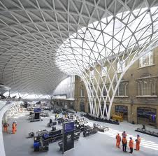
Walk through the station
concourse
This has an impressive roof with coloured lighting. A feature has
been made of Platform 9¾ which appears in the Harry Potter
books.
Exit onto Pancras Road and
bear right
The giant birdcage is an artwork by Jacque Rival called
Identified Flying Object. The German Gymnasium was designed by
Edward Grunning in 1864-5 as a club and sports facility for the
German Gymnastics Society. It was damaged by a Zeppelin Raid in
1917 and in the 1920s it provided offices for the GNR. The front
facade was demolished and rebuilt further back for the St Pancras
Station extension. It is being redeveloped for restauarnt use by
D&D London (opening 2015). The Stanley Buildings were
constructed by the Improved Industrial Dwellings Society in
1864-5 to provide self-contained housing for 104 families in five
blocks. The roofs were utilised for clothes drying and children's
play areas. One block was destroyed by WWII bombing, one removed
for road widening in the 1960s, one for works in 2001 (when the
buildings were vacated) and the fourth for the realignment of
Pancras Road in 2007. The remaining Grade II listed block will
have a six storey building constructed around it for retail and
office use.
Walk along Kings Boulevard
alongside the Gymnasium
On the left One Pancras Square is by David Chipperfield. It
has 396 columns made from recycled cast iron by the Hargreaves
Foundry in Halifax. It provides an entrance to the tube station
along an LED lit tunnel. Two Pancras Square (with roof terraces
& gardens) is by Allies & Morrison. Both provide office
and retail space. At the end is a viewing platform with
illustrated boards to identify sites.
Cross Goods Way and the
bridge over the canal
The areas alongside the canal have been re-landscaped. On
the canalside are the former Fish & Coal Offices
(1851/1860s), where clerks dealing with freight through the goods
yards worked. The buildings were gutted by fire in the 1980s.
Granary Square has 1080 computer controlled fountains with
coloured lights. The Granary was designed by Lewis Cubitt in 1852
and is now home to the University of the Arts (public access to
part of the building).
Walk along the west side of
the Granary Complex (Stable Street)
The Western Transit Shed (also by Cubitt) was used to
transfer freight to and from rail carts using cranes and
turntables. Stables were located under the loading platforms. The
building is now retail and office space. It also houses the Kings
Cross visitor centre with interactive model and information on
the area (free admission). Opposite are former coal drops (1851
& 1860s). These originally carried four high-level railway
tracks from which coal was dropped from wagons into storage
hoppers below. They were used for general storage in the 2Oth
century, later in multi tenancy use. They will be converted to
retail and food outlets.
Right along Handyside
Street.
The Platform Theatre is a performance venue for the college.
Detour left to visit the
Skip Garden
This started with a sustainable vegetable garden built in
skips and has expanded into community project which provides
opportunities for local youngsters. The fruit and vegetables
grown here are sold to local cafés and restaurants and a line of
jams and chutneys have been created. The Skip Garden hosts a pop
up cafe on the first Saturday of every month from 10am to 4pm and
there is a cosy yurt with a wood-burning stove. The Hatch Cafe
(Wed - Fri 10-3) opens onto the recreational area behind the
garden and serves a healthy menu made from organic produce grown
on site.
Return to and continue along
Handyside Street. Right through Handyside Garden
The garden was designed by Dan Pearson Studio on the site of
railway sidings. There are seats, a water feature and play
equipment amongst the planting and landscaping. To the left is
Arthouse providing 114 homes with retail units on the ground
floor.
Right to view Handyside
Canopies, Midland Goods Shed and Regeneration House (No access at present
- follow directions below)
The East Handyside Canopy was built in 1888 to provide a
covered area for potato traffic. It followed the curve of the
1850 temporary passenger terminus building, later used as a
potato market. The Midland Goods Shed was built as a carriage
shed in 1850, adpated for the Midland Railway in 1857. It was
later used by the GNR as warehousing with offices attached to the
southern front in 1870. These buildings will house a Waitrose
Store and Cookery School designed by Bennetts Associates (opening
2015). The West Handyside Canopy was built in 1888 to provide a
covered area for unloading fish. Railway traffic ceased in the
1970s. Regeneration House, was so named in the 1980s when rebuilt
following WWII bomb damage. It was originally the main Good Yard
Offices (Cubitt 1850). It has been redeveloped by John McAslan
& Partners and renamed 2 Granary Square. The House of
Illustration is here together with offices of The Art Fund.
From the garden bear left onto York Way and go right. Go down steps to the temporary towpath and follow this to the green steps back to Granary Square.
Cross back over the bridge
and go right along Goods Way
On the right is a 'living wall'. Opposite is Five Pancras
Square, the new home of Camden Council with a library, cafe,
leisure centre and swimming pools.
Right at Camley Street.
Just before the bend in
the road is the entrance to Camley Street Natural Park.
This community wildlife reserve was established in the 1980s
on the site of the Plimsoll Coal Drops and is now run by the
London Wildlife Trust [website]. Nearby is The Waterpoint on the
premises of the St Pancras Cruising Club. This was built in 1872
alongside the railway tracks to provide water to steam
locomotives and was designed at the office of Sir George Gilbert
Scott. Threatened with demolition during Channel Tunnel works in
2001 it was saved by English Heritage but had to be moved to its
present location! The lower storey had to be rebuilt but the top
two sections including the former 2,400 cubic foot water tank
(now a viewing platform) made the 700 metre journey along Camley
Street by specialist transporter. The Grade II listed Gasholder
number 8 is also being reconstructed across the canal and will
house a new park and event space designed by Bell Phillips
Architects. It was built in the 1850s by the Imperial Gas, Light
and Coke Company and formed part of the largest gas works in
London.
Resources
The Buildings of England London 4: North by Cherry &
Pevsner
Leaflets and maps from the Visitor Centre www.kingscross.co.uk
1895 OS Map http://maps.nls.uk/view/101201466
© london-footprints.co.uk 2014