Route & what to see
![]()
|
A Chelsea Walk Route & what to see |
|
london-footprints.co.uk |
This walk is circular from Sloane Square tube station (District & Circle lines) and totals 4½ miles.
From the station go
anti-clockwise around the square
The station was opened in 1868 and the Royal Court Theatre in
1888. Both were re-opened in the 1950s after suffering WWII bomb
damage. To the right in Sloane Street is Holy Trinity Church of
the 1890s by J D Sedding with an attractive Arts & Crafts
interior including an east window by Morris & Burne-Jones.
Continue along the Kings Road
On the right is the Peter Jones (now John Lewis) store,
established in 1877-84. It was rebuilt in the 1930s to the
designs of William Crabtree at which time the Star & Garter
pub fronting Sloane Square was demolished. On the left the former
Duke of York HQ was built in 1801-3 as a school for the children
of soldiers' widows by John Sanders. It has been redeveloped to
include the Saatchi Gallery.
Right at Blacklands Terrace
then left along Bray Place. Left at Lincoln Street then right
along Coulson Street. At the end go right and then first left
along Elystan Place. Just beyond the little green go left down
Godfrey Street
This street has attractive colourful houses
At the end go left along
Burnsall Street then right along the Kings Road
This passes the Old Town Hall built in 1886 by John Brydon and
extended in 1906-8 by Leonard Stokes. Since the amalgamation with
Kensington Borough in 1965 this has various uses including a
library. Opposite is the former Board of Guardians Office. The
King's Road became a private road for the sovereign in the reign
of Charles II and was only designated as a public highway in
1830.
Go left into Glebe Place and
follow this round
There are some interesting buildings in this street
including a tiny Nursery School. Number 49 was designed by
Charles Rennie Mackintosh for painter Harold Squire. Mackintosh
and his wife had studio homes at numbers 43a & 45 from
1915-23. Number 35 is by Philip Webb (1868-71).
Right into Upper Cheyne Row
A plaque here marks the site of the 18th century Chelsea
Potteries and the home of Tobias Smollett. The RC church of 1895
stands on the site of Orange House where William de Morgan had a
pottery until 1887.
Left along Lawrence Street but
detour to view Justice Walk (with former Wesleyan Chapel of 1841)
to the right
On this street are some Peabody flats and at the end a decorative
Cross Keys Pub (closed). Carlyle Mansions which have decorative
panels were built in 1896.
Right at Cheyne Walk
The medieval Chelsea Old Church was damaged by landmines in a
raid of April 1941 which killed 5 firewatchers. It was restored
by Walter H Godfrey in 1953-5. The sundial on the tower dated
1692 was remade in 1957. Facing the river is a statue of Sir
Thomas More, Lord Chancellor to Henry VIII who was beheaded in
1535.
Go right along Old Church
Street
This is the oldest street in Chelsea and has some interesting
building including the Rectory, old Wright's Dairy at number 46
and Hereford Buildings (Octavia Hill flats) opposite. These were
designed by Elijah Hoole in 1878.
At the Kings Road go left to
just beyond Paultons Square
Opposite is the Conran restaurant and shop in the former Carlyle
Garages building. This was designed in 1924 by Robert Sharp for
the Bluebird Motor Company. Separate rooms were provided for
chauffeurs, ladies and owner drivers. The main building had
workshops and space for 300 cars.
Return to and go through
Paulton Square, continuing along Danvers Street.
The houses in the square were built in the 1830s. At the end
of Danvers Street the sunken garden was laid out in 1965 on a
site occupied by houses of the 1890s, including the homes of
Whistler and Epstein, bombed in 1941. It had originally been the
site of Thomas More's orchard.
At the end go right along
Cheyne Walk, crossing Beaufort Street with care.
Crosby Hall was moved to this site from Bishopsgate in 1908. The
15th century building had been home to merchant Sir John Crosby,
Richard of Gloucester & Sir Thomas More. It was used by the
British Federation of University Women who built an adjoining
hall of residence in 1927. It now forms the eastern part of a
large private residence with designs based on other historic
properties. Battersea Bridge was designed by Sir Joseph
Bazalgette in 1890 to replace an old timber bridge. Numbers
95-100 were orginally the single Lindsey House. In 1752 this was
acquired by Court Zinzendorf as the HQ of the Moravian community
and alterations were made. After the Count's death in 1760 the
house was sold and divided up. Later residents have included the
artists Whistler & John Martin and engineers Marc & I K
Brunel.
Right along Milmans Street
At the end is the Moravian church and burial ground laid out on
the site of the stables of Beaufort House. This protestant church
movement came to England from Germany around 1750.
Cross the King's Road
This part of Chelsea is known as World's End. To the right
is The Porticos, built in 1885 by Elijah Hoole as 60 labourers'
dwellings with a central garden and shops to the Kings Road.
Continue along Park Walk then
first right into Chelsea Park Gardens
This was laid out in 1910-30 in the style of the Garden City
movement. The school is an early board school designed by ER
Robson in 1880. St John with St Andrew Church, designed in 1912
by Sir Arthur Blomfield, replaced a private chapel of 1718.
Go left at Beaufort Street and
first right into Elm Park Road
Elm Park Lane is an attractive mews to the left. Notice however
that the properties are modest in size with no rear windows.
Go right along the Vale and
first left into Mulberry Walk
The scheme to cultivate mulberries here for the silk industry
failed but a token tree has been planted outside number 21.
At the end go left along Old
Church Street and right into Carlyle Square.
At number 143 Old Church Street is the Chelsea Arts Club
Go to the right on the far
side back to the Kings Road and go left along this road.
On the opposite side are some houses of the 1720s, the
oldest in the King's Road. There are plaques to actress Ellen
Terry and director Sir Carol Reed.
Just beyond Dovehouse Street
go diagonally across the green
This green was laid out as a garden in 1977. It had been a
burial ground given to the parish in 1733 by Sir Hans Sloane and
closed in 1824. There is a plaque to 457 civilians killed in
WWII.
Continue through the Market
into Sydney Street. Go across to the chuch of St Lukes
This large church (seating 2500) where Charles Dickens was
married was designed by James Savage in 1824. It has a pleasant
churchyard park. Notice the tiny house at number 20 Britten
Street.
From Britten Street go right
down Chelsea Manor Street continuing across the King's Road. Go
right through Oakley Gardens and continue along Phene Street. Go
left at Oakley Street
There is a blue plaque to polar explorer Robert Falcon Scott at
number 56. The 'Boy with a Dolphin' sculpture was made by David
Wynne in 1975. The Albert Suspension Bridge was was built in 1873
by R M Ordish and retains its toll houses. There is a cabmen's
shelter adjacent [more info]
Go left along Cheyne Walk
Numbers 19-26 stand on the site of Henry VIII's Manor House of
1536. The Manor was later occupied by Sir Hans Sloane. There is
plaque recording this at the entrance to Cheyne Mews.
At the end of Cheyne Walk go
along Royal Hospital Road
The wall on the right is that of the Chelsea Physic Garden
Go right along Swan Walk
On the corner is a plaque recording the establishment of the
garden and further along a view through the entrance gate. The
garden is open to non-members Wednesdays & Sundays 2-5 Apl -
Oct (admission charge).
At the end go left along
Chelsea Embankment
The houses 8-11 were designed by R Norman Shaw and 4-6 by E
Godwin. There is a good view of the Bhuddist Peace Pagoda of 1985
in Battersea Park across the river.
Go left along Tite Street
Notice the lofty Tower House.There is a blue plaque on number 34
which was the home of Oscar Wilde from his marriage to
imprisonment.
At the end go right along
Royal Hospital Road
Just before the National Army Museum on the right hand side is a
section of the Berlin Wall. The museum is open daily with free
admission. It has a shop & cafe.
Just past the museum enter the
grounds of the Royal Hospital through the gate on the right.
The Royal Hospital was commissioned from Christopher Wren by
Charles II in 1682 as a home for some 400 old soldiers, in which
use it remains. On the right are stables designed by Sir John
Soane.
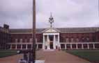
This West Road leads into
College Court. Pass through the building to the left into the
central Figure Court.
The colonnade on the north side gives access to a vestibule with
the Hall (west) and Chapel (east) open to visitors 10-12 &
2-4 daily. The statue of Charles II is by Grinling Gibbons and
has been re-gilded. The grounds down to Chelsea Embankment are
open to the public except during the Flower Show in May.
Pass through the east range of
buildings into Light Horse Court
Across from the East Road is the entrance to Ranelagh Gardens
open Mon - Sat 10-1 & 2-sunset (Sundays 2-sunset only) and
the Royal Hospital Museum open Mon - Sat 10-12 & 2-4 all year
and Sun 2-4 in summer only. Its shop sells an illustrated guide
to the Hospital.
Leave by the East Road gates
and go right along Royal Hospital Road
This passes the burial ground of the Hospital (closed in 1854)
and the new infirmary building.
At the crossroads go ahead into Pimlico Road and first left into Holbein Place which goes back to Sloane Square tube station.
© london-footprints.co.uk 2014
Resources
The Buildings of England London 3: North West by Cherry
& Pevsner